
I must first apologize for my absence the last month. As I’ve mentioned before, I work for a region of school districts for my day job. The end of summer and beginning of the school is my busiest time of the year. In my previous two posts, I explored how CBRS and Starlink can work together in a symbiotic relationship and how the two technologies perform together.
Since those posts, there has been a lot of attention given to expanding Terrestrial and Cellular networks to create “No Dead Zones”. From Starlink and T-Mobile’s announcement to Huawei to Apple, I had no idea what was coming in such a short time frame to this space. Apple is currently the only one delivering on the product starting in November with the iPhone 14 line up, but others are following on their heels. Personally, I’m anxious to get my iPhone 14 Pro that is preparing to ship for arrival this Friday. These technologies are going to save lives. I’m excited to personally have that option as a backup while I’m in the back country hiking, jeeping, or snowmobiling.
While it’s not something I plan to use every day. Apple’s announced iPhone to Satellite connectivity has completely different use cases than my previous posts because of the low data rates allow by a cell phone connecting to a satellite. The current announced iterations will provide emergency messaging services only and are SLOW. Starlink and CBRS can provide connectivity for higher bandwidth applications across a smaller area but from anywhere you have an unobstructed view of the sky.
After my previous posts, I was approached by a group called the Information Technology Disaster Resource Center (ITDRC). https://www.itdrc.org/. They found my posts intriguing and are exploring using these technologies together in disaster scenarios to get communications back up quickly.
Interestingly enough, the very first use case that came to my mind when I started exploring Starlink and CBRS together was a mobile disaster command center. I later found out that such vehicles are called COWs or COLTs.
A Cellular Barnyard, COWs and COLTs
For years, first responders and news media outlets have built networks connecting through satellites with massive dishes attached to the top of vehicles with or without cellular connectivity. Getting connectivity to a remote location for getting information to other first responders or sharing an onsite broadcast on the local news is a proven use case. When you take a Cellular RAN and connect it to a mobile unit it is often called a Cellular On Wheels (COW) or Cellular On Lite Transit (COLT).
The picture below was our first attempt at building our own CBRS COW. We built it for a conference at Bryce Canyon to broadcast connectivity to the hotel across the street. We had hardwired Internet connectivity tethered to the building, so, we didn’t have to connect it using Starlink. Adding that functionality would have been an easy additional step. Starlink at the time wasn’t allowing roaming, but Roaming is fully allowed now for an additional fee. If you are going to build a COW you will want a Starlink plan with a roaming plan.
* As a quick aside, COW has another definition that is gaining traction in recent years during disaster incidents. That definition is Cellular on WINGS. The benefit of a Cellular Radio attached to a ground tethered Drone can be a game changer in a disaster scenario to get cellular connectivity up high until ground stations can be restored.
* When it comes to broadcasting in the CBRS Band in the US, COWs with a Cellular RAN attached to an Aerial Drone are PROHIBITED. Attaching a CBRS radio to a vehicle is only allowed while the vehicle is stationary as someone with a CPI has to certify the Height Above Average Terrain (HAAT), Latitude and Longitude, and other critical data points to protect surrounding incumbent networks.

Growing Starlink Use Cases
Starlink is expanding satellite connectivity to RVs and Boats. While controversy follows Starlink as I explained in a previous post, the benefits of Starlink are becoming a game changer. Back in May, Elon Musk tweeted the following tweets:
As I talked about in my previous post, at my day job, we are using Starlink to connect up schools and remote sites until we can get eRate funding to connect them with Fiber or licensed microwave. I recently saw an NBC News article about a remote tribal school district in Arizona that used CARES funding to provide connectivity to homes so students could do their homework and attend school. Public cellular networks don’t reach many of the homes in that district and there was only one usable service. That school will soon run out of funding to continue supplying the Starlink terminals, and they are trying to find funding to maintain the program.
Post Covid, many people are asking how Satellite internet can bridge the digital divide. During COVID lockdowns, a lot of schools would take unused school buses that had cellular connectivity and park them in communities to bridge the digital divide. If we combined all these ideas, we arrive at a CBRS COW or COLT. We are exploring additional educational specific use cases that could benefit from a COW or a COLT. We are looking into purchasing or building a more permanent COW that can travel. It opens up new educational possibilities.
COLTs and COWs are used extensively by carriers when there are a large influx of users into an area temporarily. I see search and rescue or private entities in a remote location using CBRS to aid in the search for lost persons or any other number of use cases.
In December 2021, I attended Fierce Wireless’s Digital Divide Summit where they talked extensively about the upcoming use cases for connecting devices via Satellites for reaching people from anywhere. The views discussed during that Summit were the precursors to the technologies being released today by Apple, T-Mobile, and Starlink.
CBRS COLT Thoroughbred
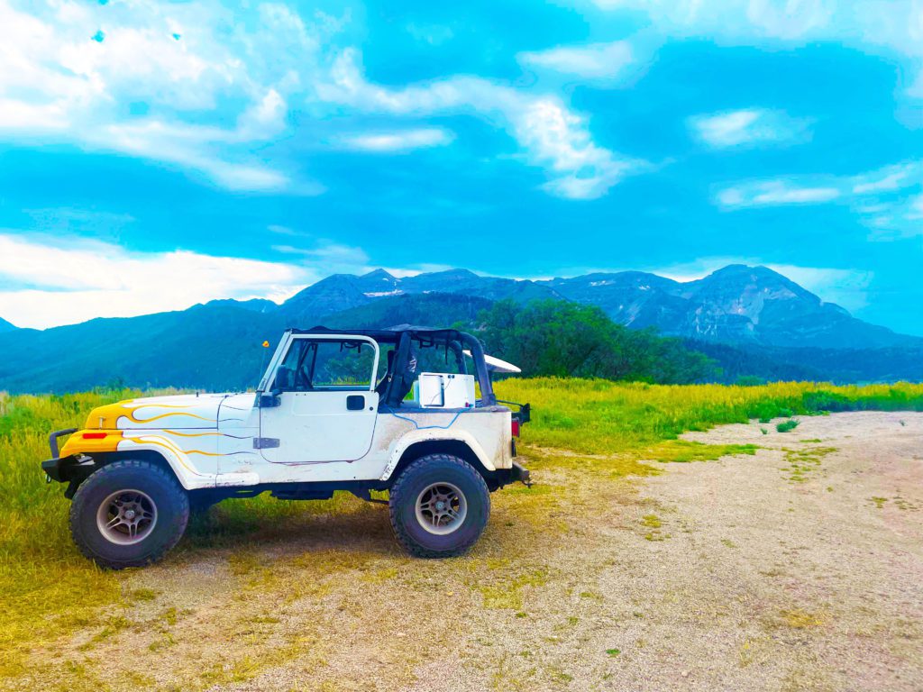
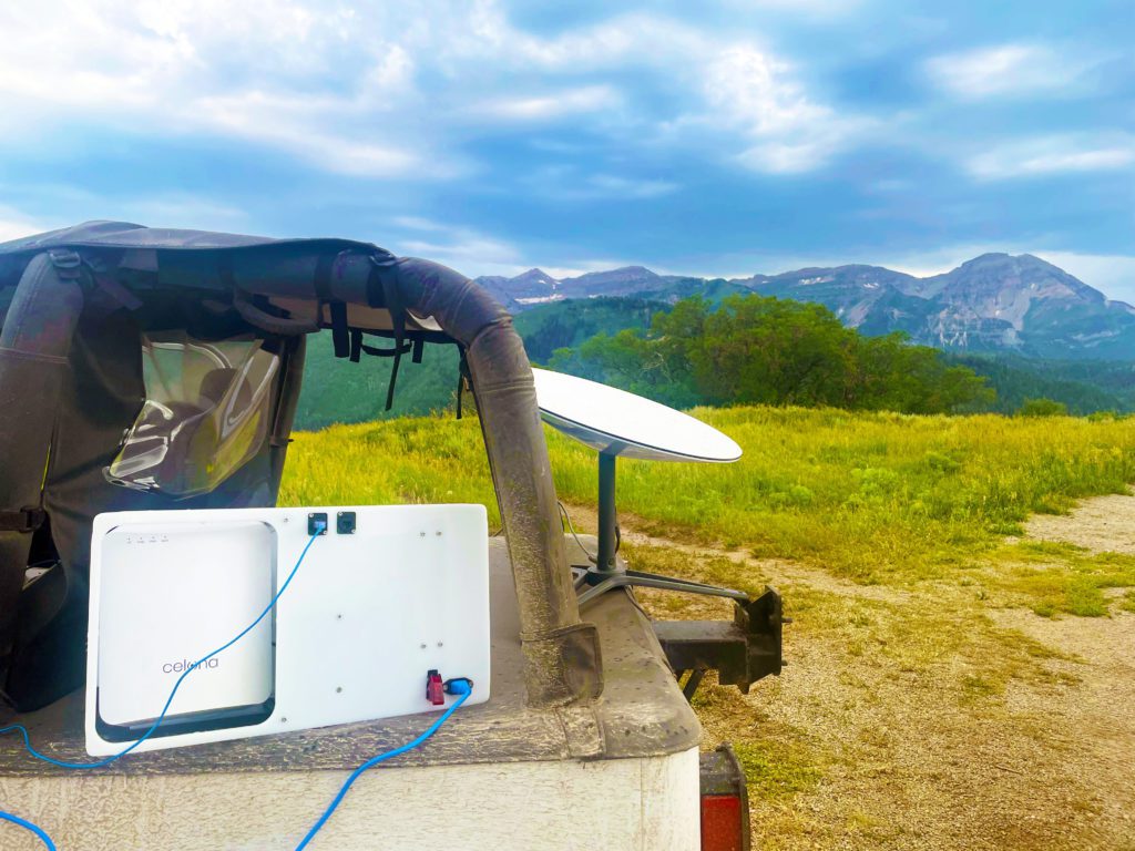
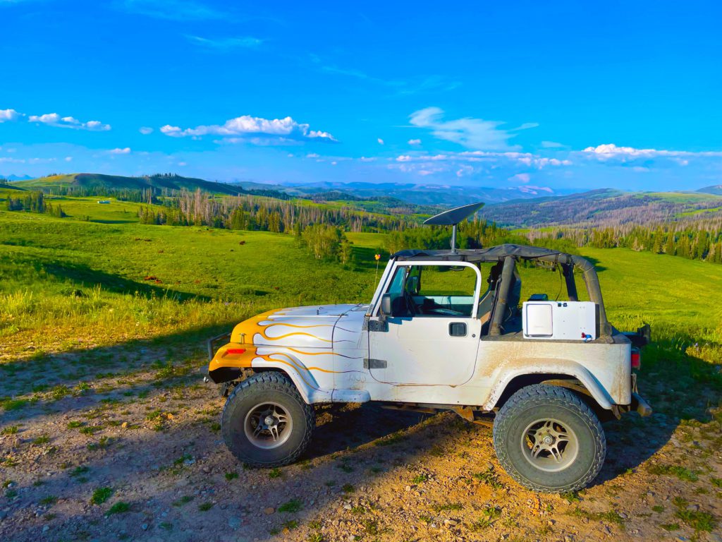
Before we get our own COLT, I decided to try my hand at building a mobile CBRS COLT with my ’92 YJ Jeep Wrangler. Elon Musk in that tweet said the dish is too large for a small vehicle.. All the equipment took up my whole passenger seat. It was definitely tight fitting everything in in a compact vehicle, especially with the back seat removed. As I’ve used in my other posts, I used the Celona Air Kit that fits nicely in a Pelican Case. Sadly, the Starlink Dishy, Injector, and Router doesn’t fit so cleanly in a single case for transport.

My Jeep YJ has a Bikini Top. So, I decided to try placing the Dishy on top of the canopy, and the Celona Air Kit on the deck cover on the back of my Jeep. I powered everything through a portable solar generator battery. The different devices are pretty power hungry and will drain a small battery in a few hours. I could have ran everything off a power inverter or off a regular gas generator, but the solar generator was sufficient for my testing purposes. I attempted to use the solar panels attached to my solar generator to maintain the battery, but the solar generator that I chose does not allow the simultaneous charging and usage. Plus the panels that I have are insufficient to keep up with the power draw requirements of the setup. You would need larger batteries and panels to maintain this setup over a long period like this guy built. It works great to stand up a temporary CBRS COW network.
A Lame COLT in the Field
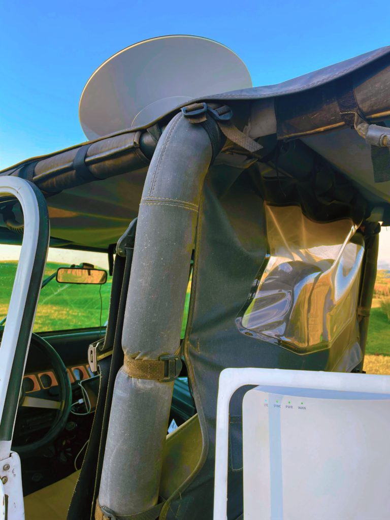
There are a couple limitation when it comes to a remote CBRS network. First, with CBRS there is an important piece that you can’t avoid, that is the Spectrum Access Service or SAS. SAS is a database of all the authorized radios broadcasting in the CBRS band which controls all aspects of the cellular network including if you can even broadcast at all. Beyond the regulations restricting it, this is why you can’t build a CBRS network that is aerial or moving. The SAS database requires an exact location including height above the ground or height above average terrain (HAAT) for all radios before the SAS authorizes a radio to broadcast. That data has to be input to the vendor’s management portal by someone who has a CPI or Certified Professional Installer credential.
Second, is a limitation of Celona and a lot of tools. Celona Orchestrator was built to use actual addresses when placing a radio to ease the configuration. This becomes an issue if you are installing your CBRS Radio at a site that doesn’t have an actual address, like say the side of a mountain. I had to move my radio a few times to get an actual address to register the radio with SAS.
I finally had success after a few attempts. The picture above shows the Blue and Green LEDs on the Celona Air radio meaning I correctly used my CPI to enter the information into Celona’s Orchestrator, the device received a Grant from the SAS, and was authorized to broadcast. I was able to connect my iPad Pro to the Cellular network and browse the internet in a site where I had no cellular connectivity through the regular public cellular carriers. I even unexpectedly was able to test “Wifi Calling” over CBRS when I receive an incoming call and had a decent call experience over Starlink.
A third limitation also comes because of SAS. If you want to test building a CBRS COLT or COW with Celona gear or other vendors, I recommend that you set your coordinates in SAS before hand. Depending on the SAS provider and CBRS vendor, it may take up to 24 hours for your radio to get a license grant from the SAS. My COLT failed a few times while trying to get my COLT up and connecting because I tried to set the coordinates on site.
If you know you are going to stand up a radio at a certain location, entering that information into the SAS a day before will greatly improve the time for the rollout. These networks are not as mobile as a Wifi network for this reason.

My recommendation, set the SAS information as soon as you know the location of your COW or COLT.
* You can stand up a Starlink and CBRS network anywhere you can get connectivity with Starlink within the United States as the CBRS band is only authorized within the US.
Planting the Wireless Pasture, Wifi vs CBRS Coverage

Let visualize the coverage using a couple of industry standard tools: Google Planner, Ekahau AI Pro, and Hamina. I have tested my COLT on several mountains around my home. For simplicity sake, let’s use the following coordinates: 40.400855, -111.183011. Those coordinates are where I took this picture, and behind me is a slope up to the top of the mountain that is casting the shadow. The back country and peaks of the High Uintah mountains are off in the distance with little to no cellular connectivity as far as you can see.
Google Planner Tool
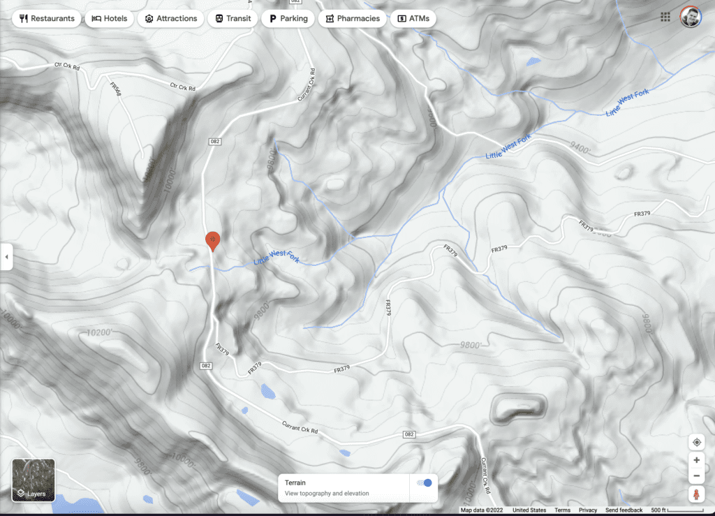
The Google Planner is an excellent tool for planning and visualizing a CBRS network coverage outdoors. It only works with Cellular networks so it can’t be used to visualize Wifi Networks. If we select the location and input the antenna data of the Celona Air Kit omni directional antennas, we get the following diagram. Since it’s owned by Google, they use Lidar from Satellites to create a visualization with topographical data as well as trees and buildings. From my little test COLT scenario, I would have had coverage across the mountain side as you can see.
Because it was a large area and I only had a single vehicle, I didn’t take my CBRS Pi tools to walk around and see what my coverage was. Although, I did do some small tests with my CBRS Pi around my COLT. CBRS, because of the higher power allowances, can reach a lot farther than an omni Wifi radio. If we were to visualize this with a directional sector antenna attached to Celona’s outdoor radios you could see coverage at miles away. Our record is over 10 miles over open flat terrain. With the terrain of this mountain, I could have gotten a couple miles out of a sector antenna.

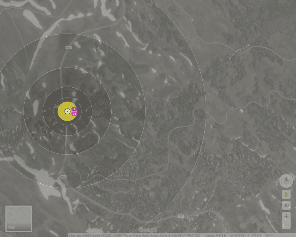
Ekahau AI Pro
Ekahau AI Pro is the newest update from Ekahau. It only visualizes Wifi networks at this point… It has become the gold standard for designing and measuring Wifi networks but is starting to get some competition. I took a screenshot of the above Google Planner and input it into Ekahau AI Pro. As Ekahau doesn’t have the Lidar and Topographical data that Google has, it only shows as a flat plane. The limited data shows sufficient information to compare Wifi against CBRS.
I input a generic 2.4/5Ghz radio as it doesn’t have Starlink’s router as an official Access Point. As is natural with an omni antenna with the low power of Wifi, I would have had connectivity only a few hundred feet away from my Jeep COLT within the green, yellow, and orange areas.
Like I mentioned with the Google Planner above, using sector antennas with Wifi I could have probably gotten a couple miles. The difference is the beam width of the signal. CBRS with the higher power allowances, allows you to reach further with a wider beam width. We are using 60 degree sector antennas or more with CBRS; while, the P2P Wifi directional antennas we are using are 45 degree or less.
Hamina
Finally, Hamina is a new comer to the Wifi and Private 5G space. The Hamina planner tool provides insights for both Wifi and Private 5G/LTE so we can use one tool to visualize and compare both. Like Ekahau, Hamina doesn’t have access to the depth of data that Google uses in their tool. You have to add trees and foliage manually. The product is also in Beta. So, it is still in development.
The differences between CBRS and Wifi are quickly noticeable when comparing the results on a single tool. I chose the Celona AP-10, as that is the included Radio in the Celona Air Kit, and a Microtik wAP, to visualize the Starlink Router that I used on site.

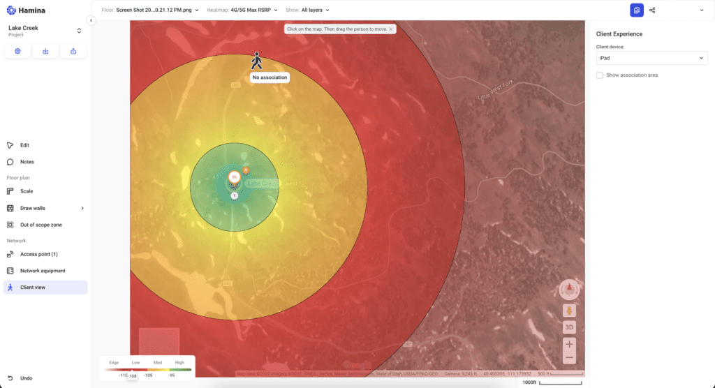
For now, Hamina’s Client View doesn’t show an association on the Client Stick Figure (or Walrus) when connected to Private LTE/5G even when signal strength would be sufficient for connectivity. It does show connectivity if within range of the Wifi radio.
For my above example at almost 2,000 feet away, the Wifi connected iPad wouldn’t have a chance; while the CBRS connected iPad would possibly have okay connectivity. If you look at that same location in the above Google Planner result, it shows that you might have signal at -100 to -110dbm. Since how cellular technologies function and are measured, you can have usable RSRP signal down to the -120dbm range before a device starts to lose connectivity. Wifi on the other hand starts to struggle past -80dbm RSSI with -65dbm or better being optimal.
Blue Ribbon COLT, Winning Results
My testing of my personal CBRS COLT was a full success. The actual Cows in the background would have been quite happy with their Private LTE connectivity from my CBRS COLT. I learned a lot and discovered that there are a lot of limitations as I’ve mentioned.
I clearly see organizations like the ITDRC, first responders, search and rescue, municipalities, school districts, and others building COWs or COLTs for use at events or during disasters. These technologies work together and provides connectivity in a different way than the recently announced options from the likes of Apple and T-Mobile.
All these technologies, CBRS, Wifi, Satellites, Cellular can be complimentary and not necessarily competitive. Ask yourself, what is the best form of connectivity for your devices for that specific use case and moment?